Tanggu Maps
You can find out the city on the north-central part of China's map. Tanggu District is a district in the Tianjin municipality on the coast of northeastern China. It is on the Hai River where it enters the Bohai Sea, and is a port for Tianjin, which is about 30 miles (48 km) upriver. The Tianjin Economic-Technological Development Area is within the city limits. Its population is approximately 450,000.
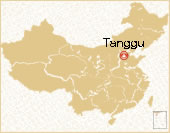 Tanggu Location Map
 Pre | Next
Your Question & Quick Answer*We welcome and appreciate your questions & reviews


Booking Procedures | Terms & Conditions | Payment Methods | Links | Site Map | About Us | Contact Us | Travel Agent
Copyright 2008, All rights reserved.. itourbeijing.com ,china map, china cities maps
TEL: 86-10-85711972 (Universal) 1-888-288-9328 (North America) E-mail: contact@itourbeijng.com
Home | China Tours | Beijing Tours | Tibet Tours | China Travel | Beijing Travel | Shanghai Travel