China Maps
Have a good knowledge of China Maps is a prerequisite to your trip in this vast country. As one of the world's largest countries in total area, China enjoys a large range of variety in its terrain from the western plateau to eastern coast; from the northern grassland to the southern islands. In this section, Itourbeijing.com includes various maps of China, ranging from the country map, province maps, city maps, ancient maps, historical maps, to special and topical maps and many more. From these maps you can find the exact locations of the major cities and some famous tourist attractions in different area of China. Hope these maps can help plan your trip in China.
City Maps
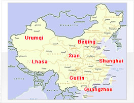
The City Maps provide a big collection of maps of the major cities in China. We mark on the Map of China with the major cities and fomous tourist destinations, like Beijing, Xi'an, Shanghai, Guilin, Chengdu, Shenzhen, Guangzhou, Hong Kong, Lhasa and etc. From these maps, you can find the exact location of different cities in China.
- Baotou
- Beidaihe
- Beihai
- Beijing
- Changchun
- Changsha
- Chengde
- Chengdu
- Chongqing
- Dali Map
- Dalian
- Datong
- Dunhuang
- Erdos
- Fuzhou
- Guangzhou
- Guilin
- Guiyang
- Gyangtse
- Haikou
- Hailar
- Hangzhou
- Harbin
- Hefei
- Hetian
- Hohhot
- Hongkong
- Huangshan
- Jilin Map
- Jinan
- Jiuquan
- Jiuzhaigou
- Kaili
- Kashgar
- Korla
- Kunming
- Lanzhou
- Leshan
- Lhasa
- Lijiang
- Luoyang
- Macau Map
- Manzhouli
- Nanchang
- Nanjing
- Nanning
- Ningbo
- Pingyao
- Putuoshan
- Qingdao
- Qinhuangdao
- Rongjiang
- Sanya Map
- Shanghai
- ShangriLa
- Shaoshan
- Shaoxing
- Shegar
- Shenyang
- Shenzhen
- Shigatse
- Shijiazhuang
- Suzhou
- Taipei
- Taiyuan
- Tanggu
- Tianjin
- Tianshui
- Turpan
- Urumqi
- Weihai
- Wuhan
- Wuwei
- Wuxi Map
- Xiamen
- Xian Map
- Xingang
- Xining
- Xuchang
- Xuzhou
- Yangshuo
- Yangzhou
- Yichang
- Yinchuan
- Yiwu Map
- Yutian
- Zhangjiajie
- Zhangmu
- Zhangye
- Zhaoxing
- Zhengzhou
- Zhongdian
- Zhongwei
- Zhuhai
China Province Maps
China Province Maps provide you the clear maps of different provinces in China like Beijing, Tibet, Guangdong, Shanghai, Shandong, Fujian, Zhejiang, Jiangsu and Sichuan... Not only the location of the provinces are shown in China's Map, but also the major cities in every province are all available.
- Anhui Map
- Fujian
- Gansu
- Guangdong
- Guangxi
- Guizhou
- Hainan
- Hebei
- Heilongjiang
- Henan
- Hubei
- Hunan
- Inner Mongolia
- Jiangsu
- Jiangxi
- Jilin Province
- Liaoning
- Ningxia
- Qinghai
- Shaanxi
- Shandong
- Shanxi
- Sichuan
- Taiwan
- Tibet Map
- Xinjiang
- Yunnan
- Zhejiang
Your Question & Quick Answer*We welcome and appreciate your questions & reviews
China Maps
Related Links
Our Service


Booking Procedures | Terms & Conditions | Payment Methods | Links | Site Map | About Us | Contact Us | Travel Agent
Copyright 2008, All rights reserved.. itourbeijing.com ,china map, china cities maps
TEL: 86-10-85711972 (Universal) 1-888-288-9328 (North America) E-mail: contact@itourbeijng.com
Home | China Tours | Beijing Tours | Tibet Tours | China Travel | Beijing Travel | Shanghai Travel