Weihai Maps
You can find out the city on the eastern part of China's map. Weihai,was known during the colonial period as the Weihai Garrison or Weihaiwei, and sometimes as Port Edward; is a prefecture-level city in eastern Shandong province. The easternmost prefecture-level city in the province and a major seaport, Weihai borders Yantai to the west and the Yellow Sea to the east.
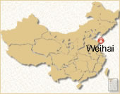 Weihai Location Map
 Pre | Next
Your Question & Quick Answer*We welcome and appreciate your questions & reviews


Booking Procedures | Terms & Conditions | Payment Methods | Links | Site Map | About Us | Contact Us | Travel Agent
Copyright 2008, All rights reserved.. itourbeijing.com ,china map, china cities maps
TEL: 86-10-85711972 (Universal) 1-888-288-9328 (North America) E-mail: contact@itourbeijng.com
Home | China Tours | Beijing Tours | Tibet Tours | China Travel | Beijing Travel | Shanghai Travel