Hubei Maps
Hubei Province is situated in central China, extending across China's major river systems – the Yangtze River. It is surrounded by Henan Province to the north, Jiangxi and Hunan to the south, Anhui to the east, Sichuan to the west and Shaanxi to the northwest. Our province map marks the important cities in Hubei which lies along the Yangtze River, including the capital city Wuhan and Yichang, the main port for Yangtze Cruise.
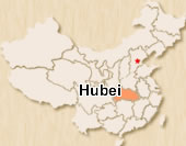 Hubei Location Map
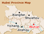 Hubei Province Map
 Pre | Next
Your Question & Quick Answer*We welcome and appreciate your questions & reviews


Booking Procedures | Terms & Conditions | Payment Methods | Links | Site Map | About Us | Contact Us | Travel Agent
Copyright 2008, All rights reserved.. itourbeijing.com ,china map, china cities maps
TEL: 86-10-85711972 (Universal) 1-888-288-9328 (North America) E-mail: contact@itourbeijng.com
Home | China Tours | Beijing Tours | Tibet Tours | China Travel | Beijing Travel | Shanghai Travel