Inner Mongolia Maps
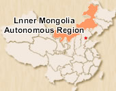
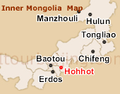
Inner Mongolia, China's northern border autonomous region features a long, narrow strip of land sloping from northeast to southwest. It neighbors eight provinces and regions in its south, east and west and Mongolia and Russia in the north, with a borderline of 4,200 km. The capital city Hohhot and the other two major cities Baotou and Erdos are near each other from the map.

 Pre | Next
Your Question & Quick Answer*We welcome and appreciate your questions & reviews


Booking Procedures | Terms & Conditions | Payment Methods | Links | Site Map | About Us | Contact Us | Travel Agent
Copyright 2008, All rights reserved.. itourbeijing.com ,china map, china cities maps
TEL: 86-10-85711972 (Universal) 1-888-288-9328 (North America) E-mail: contact@itourbeijng.com
Home | China Tours | Beijing Tours | Tibet Tours | China Travel | Beijing Travel | Shanghai Travel