Jiangxi Maps
As one of China's inland provinces, Jiangxi is located in the southeastern part of the country, on the southern bank of the Yangtze River. It borders Zhejiang and Fujian in the east, Guangdong in the south, Hunan in the west and Hubei and Anhui in the north. Its capital city is Nanchang. Jingdezhen, on top part of the Jiangxi Province Map, is a town famous for its porcelain and teapot.
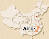 Jiangxi Location Map
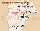 Jiangxi Province Map
 Pre | Next
Your Question & Quick Answer*We welcome and appreciate your questions & reviews


Booking Procedures | Terms & Conditions | Payment Methods | Links | Site Map | About Us | Contact Us | Travel Agent
Copyright 2008, All rights reserved.. itourbeijing.com ,china map, china cities maps
TEL: 86-10-85711972 (Universal) 1-888-288-9328 (North America) E-mail: contact@itourbeijng.com
Home | China Tours | Beijing Tours | Tibet Tours | China Travel | Beijing Travel | Shanghai Travel