Qinghai Maps
Qinghai province lies on the northeastern part of the Qinghai-Tibet Plateau in west China, bordering Gansu and Sichuan provinces, Xinjiang Uygur Autonomous Region and Tibet Autonomous Region. As the origin of the Yangtze, Yellow, and Lancang rivers, its territory includes grassland, cultivated land and forest. Our map shows that the provincal city of Xining is the main entry port by airflights and Xining holds a section of the Railway to Lhasa.
 Qinghai Location Map
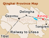 Qinghai Province Map
 Pre | Next
Your Question & Quick Answer*We welcome and appreciate your questions & reviews


Booking Procedures | Terms & Conditions | Payment Methods | Links | Site Map | About Us | Contact Us | Travel Agent
Copyright 2008, All rights reserved.. itourbeijing.com ,china map, china cities maps
TEL: 86-10-85711972 (Universal) 1-888-288-9328 (North America) E-mail: contact@itourbeijng.com
Home | China Tours | Beijing Tours | Tibet Tours | China Travel | Beijing Travel | Shanghai Travel